Sunday, August 10, 2014

178. Europe Bicycle Trip--Burg Maus, Burg Sterrenberg, Burg Liebenstein and the Town of Boppard

What a beautiful day I have today for bicycling through this beautiful part of the Rhine. It is a section that most tourists pass through, including my sister, Josephine and her husband John, last year on their barge trip.
The Rhine River with Burg Maus up on the hill in the distance..
More of Burg Maus with Wellmich village in the foreground.
Burg Maus- Construction of the castle was begun in 1356 by Archbishop- Elector of Trier Bohemond II and was continued for the next 30 years by successive Electors of Trier. The construction of Burg Maus was to enforce Trier's recently acquired Rhine River toll rights and to secure Trier's borders against the Counts of Katzenelnbogen  (who had built Burg Katz and Burg Rheinfels just south of here) In the latter half of the 14th century Burg Maus was one of the residences of the Elector of Trier. Burg Maus was never destroyed though it fell into disrepair in the 16th and 17th centuries. Restoration of the castle was undertaken between 1900 and 1906 with attention to historical detail. The castle suffered further damage from shelling during World War II which has since been repaired. Today Burg Maus hosts an aviary that is home to falcons, owls and eagles and flight demonstrations are staged for visitors. Local folklore attributes the name Burg Maus (the Mouse) to the Counts of Katzenelnbogen's mocking of the Electors of Trier during the 30 years of construction saying that the castle was the "mouse" that would be eaten by the "cat" of Burg Katz.
Bicycling past Zu Fellen and Hirzenach on this side of the river and Ehrenthal and Kastert on the other side of the river and heading towards Bad Salzig on this side and Kamp Bornhofen on the other side.
The Rhine Gorge is a popular name for the Upper Middle Rhine Valley , a 65 km. section of the river Rhine between the cities of Bingen and Koblenz. It was added to the UNESCO list of World Heritage Sites in June 2002 for a unique combination of geological, historical, cultural and industrial reasons. - Tour boat docks, barges and castles --Two more castles coming up on the other side of the river
On the left-Burg Sterrenberg und Streitmauer and on the right -Burg Liebenstein. Burg Sterrenberg  (on the left)    was mentioned as an imperial castle by 1034. It was a feudal system castle. The noble family of Bolanden stayed as lords of Sterrenberg Castle until the second half of the 13th century. From this early period, the bergfried (tall tower found in medieval castles) and the first , inner shield wall have survived. Today Burg Sterrenberg houses apartments and a restaurant.                                                           
Burg Liebenstein- It is thought that Liebenstein Castle was once part of Sterrenberg Castle, belonging to the feudal lords of Bolanden. The castles were expanded over the centuries, but in the 14th century, a 2.5 meter "conflict wall" was built-directed against Liebenstein castle-giving rise to the myth of the " enemy brothers". Sons of a count, the lords of Bolanden, brothers, cheated their blind sister out of her inheritance following the death of their father. They became bitter enemies and built a wall to divide the two castles. It didn't take long for them to lose their inheritance, and when they tried to reconcile, one accidentally killed the other. The surviving brother traveled to the Holy land and died there. In 1529, the castle was barely habitable and was abandoned by the end of the century. The property fell once again into inheritance disputes this time between Emperor Ferdinand II and the House of Nassau-Saarbrucken. Finally, in 1793, a Baron Preuschen acquired the castle and his descendants oversee it today. Today it is a hotel and restaurant.
Bad (Bath) Salzig is a spa town with  springs that dispense slightly salty water. Captain Theodor Hoffman started the drillings for spa springs. Between 1902 and 1905, the "Barbara" and "Leonoren" Springs were found.  The Leonoren Springs are 446 meters deep. Bad Salzig is also home to Sebamed, Germany's largest producer of soap-free toiletries and cosmetics. The mild climate and the long hours of sunshine are favorable for growing fruit, especially cherries. The castles, Sterrenberg and Liebenstein , popularly known as the "Hostile Brothers" are to be seen on the opposite side of the Rhine.  Archeological finds show that Bad Salzig was situated on the historic Roman Road which went from Mainz to Cologne in the 2nd and 3rd centuries.
Entering Boppard-Gemeindezentrum--A community meeting center for community gatherings of various ages , religious instruction, adult education, cultural events, seniors encounters, youth work, for meetings of groups and clubs such as church choirs and musical groups for parties and celebrations.

Old stone city wall
Boppard is a state-recognizesd tourism resort and is a wine growing center, attracting tourists with many lodging and dining businesses. Boppard is the biggest wine growing center in the Middle Rhine wine region. Grown here are Riesling, Muller-Thurgau and Pinot noir.  From Boppard excursion ships sail on the Rhine to the Loreley and to Rudesheim along the loveliest stretch of the whole Rhine Valley with its many castles. . Directly north of Boppard, the Rhine takes its greatest bend. This bow in the river is called the Bopparder Hamm , the same name given to the wine growing area. Boppard's town forest is the second biggest in Rhineland-Palatinate. The big city of Koblenz is 22km. away.
I have not been able to find any information on this man. If you do, let me know please.
Hotel Ebertor and  Restaurant Klosterkeller
Viking River Cruises dock in Boppard-I think that my sister must have docked here.
Villa Belgrano- representative brick building, Renaissance Revival 1890; whole complex of buildings with garden
Anno (Year) 1787
Looking back at Boppard-St. Severus's Church steeples rising high in the sky-- if I came again I would spend more time here.
Anno 1737
A small shrine
Filsen-across the river from Boppard

Thursday, August 7, 2014

177. Europe Bicycle Trip--Castles Galore--Pfalzgrafenstein, Gutenfels,Schonberg and Katz Castles

I was an early bird today and up at 4:30 so I had a very early start on Day 63, June 18th,2014. I will be going along a very beautiful stretch of the Rhine River with the bicycle path along the water and hills going up on both sides of the river.
The vineyards of Bacharach
A memorial in Bacharach of a victory in battle for Prussia and the German motherland in 1813
A castle in the foreground (Pfalzgrafenstein) and a castle up on the hill (Gutenfels) above the town of Kaub on the river opposite my bicycle path
Close up of Pfalzgrafenstein Castle It as a toll castle shaped like a boat on Pfalz Island in the middle of the Rhine near the town of Kaub. The castle was built in 1326 to 1327. The point of the stone boat is upstream. Around the tower, a defensive hexagonal wall was added in 1338. Later additions were made in 1607 and 1755, consisting of corner turrets, the gun bastion pointing upstream and the characteristic baroque tower cap. A chain across the river forced ships to submit and uncooperative traders could be kept in the dungeon which was a wooden float in the well. They were held until a ransom was produced. The "Pfalz" was never conquered or destroyed withstanding not only wars but also the natural onslaughts of ice and floods by the river. After toll collections stopped in 1867, it continued to be used as a signal station for boat traffic for another century. In 1946, it became the property of the state-Rhineland-Pfalz which turned it into a museum and restored the color scheme of the baroque period. It is assessed by ferry.
Behind the toll castle is the town of Kaub and on the hill above is Gutenfels Castle
Close up of Gutenfels Castle-The name Gutenfels means "solid rock". It is 110 meters above the town of Kaub and was built in 1220. It was used with Pfalzgrafenstein castle in the middle of the river and with the fortified town of Kaub to provide an impenetrable toll zone for the Holy Roman Empire until Prussia purchased the area in 1866 and ended the toll in 1867. Today Castle Gutenfels is a hotel.
On the way to Oberwesel
Panorama view of Highway 9, the bicycle path and the Rhine River
Entering Oberwesel- Liebfrauenkirche (church) in the distance on the right and Schonburg Castle on the hill on the left
Schonberg Castle was built between 1100 and 1149. From the 12th century, the Dukes of Schonburg ruled over the town of Oberwesel and also had the right to levy customs on the Rhine River. In the 17th century the Schonburg line died out. The castle was burned down by French soldiers in1689 during the Palatinate wars. It remained in ruins for 200 years until it was acquired by the German-American family who bought  the castle from the town of Oberwesel in the late 19th century and restored it. The town council of Oberwesel bought the castle back from the Rhinelander family in 1950. Since 1957, the Huttl family have been living at the castle on a long term lease. They operate a successful hotel and restaurant there.
Zoom on Schonburg Castle
Old tower
A large barge passing in front of a double train tunnel on the other side of the river
The oxen tower (Ochcenturm) in Oberwesel, Germany is a medieval tower that dates back to the Roman period.
Kammerck Train Tunnel -289 meters in length next to Urbach
Even the ends of the train tunnels look like castles.
Approaching Sankt Goar
Katz Castle above the town of St. Goarshausen on the other side of the river
Close up of Katz Castle (Burg Katz)-The magnificent castle stands on a ledge looking downstream from the riverside at St. Goars. It was first built around 1371 by Count William11 of Katzeneinbogen. The castle was bombarded in 1806 by Napoleon and rebuilt in the late 19th century ,between 1896-98.It is now privately owned and not open to visitors.
Approaching Sankt Goar
Burg Rheinfels from a distance-Burg Rheinfels is a castle ruin located above the left (West)  bank of the Rhine in Sankt Goar. It was started in 1245 by Count Diether V of Katzenelnbogen. After expansions , it was the largest in the Middle Rhein Valley between Koblenz and Mainz. It was partially destroyed by French Revolutionary troops in 1797. It is the largest castle overlooking the Rhine and historically covered 5 times its present area. While much of the castle is  a ruin, some of the outer buildings are now a luxury hotel, wellness center and restaurant. There is also a museum.
Close up of Burg Rheinfels

Monday, August 4, 2014

176. Europe Bicycle Trip-- Castle Stahleck and Leo and Mia From Brabant

I set up my tent and walked through the campground. The caravans with motors had to park in this paved parking lot.
I had supper in the campground restaurant and worked on blogs . I had this delicious dutch apple pastry and whipped cream and ice cream for dessert.
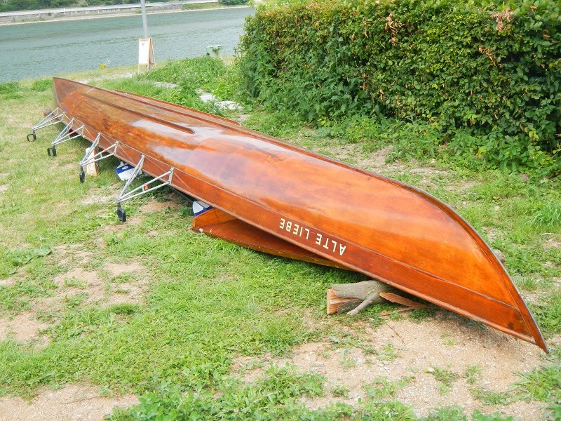
I continued my walk and went past this trailer for the Bacharach Ruderwerein (Rowing Club)
This is a beautifully handcrafted rowing shell.
I walked up to the main street of Bacharach to take a photo of the nice downtown with the Castle Stahleck looming above it.it The town of Bacharach is first mentioned in books in the 11th century.  It was important in the 12th century as a toll and revenue centre.  In the 13th century it became important as a transfer point for the wine trade, as barrels were offloaded herefrom the smaller ships that were needed to get by the Binger Loch ( a quartzite reef in the Rhine upstream near Bingen) and loaded onto bigger ones. From then on the wine bore the designation Bacharacher. The timber trade from Hunsruck was also important. Today the area thrives on tourism and the wine trade from here is still enjoying international popularity.
Castle Stahleck is a 12th century fortified castle in the Upper Middle Rhine Valley at Bacharach in Rhineland Palatinate, Germany. It stands on a crag approximately160 meters  (520 feet)above sea level on the left bank of the river of the Steeg Valley. it offers an outstanding view of the Loralei valley.Its name means "impregnable castle on a crag"from the Middle High German words stahel (steel) and ecke (crag). It has a water-filled partial moat, a rarity in Germany. it was destroyed in the late 17th century but rebuilt in the 20th and is now a hostel.
Close up
Later in the evening, Leo and Mia from Brabant, Netherlands who I had met earlier had arrived back to their caravan from their bicycle ride and I stopped in to visit them. We enjoyed a nice cup of tea together and it was so nice to talk Dutch with them after being in Germany for over a week. I need to speak Dutch every day to keep remembering all the words. I got some extra duct tape from them to replace what I had used on my bicycles on my flat tires. I gave them my card and it was dark when I returned to my tent. It had been a long eventful day.

Sunday, August 3, 2014

175. Europe Bicycle Trip--Assmannshausen and Burg Ehrenfels


A barge from Holland called Goblin. Most of the barges on the river are from the Netherlands.
Mile marker 537
Two tour boats
Viking cruise barge just like my sister, Josephine and husband John took last fall from Budapest to Netherlands.
Assmannshausen since its incorporation in 1977 is a quarter in Rudesheim am Rhein in the Rheingau located on the Rhine in the state of Hesse. A chairlift in Assmannshausen gives  a view of the vineyards and the castle Rhienstein on the other side of the river.
Close up
Panorama
The vineyards above Assenhausen
In the distance across the river is Burg Ehrenfels
Zoom shot of Burg Ehrenfels- Ehrenfels Castle is a ruined castle above the Rhine Gorge near the town of Rudesheim am Rhein in Hesse. It is located on the steep eastern bank of the river amid extended vineyards. The grape variety Ehrenfelser is named after the castle. It was rebuilt in 1212 by the Archbishop of Mainz as a defensive work against attacks by  Elector Palatine Henry V. The Archbishop staffed the castle erected a customs post controlling the shipping on the river. It was heavily damaged in the 30 years war and finally devastated in 1689 by French troops. It can only be reached by a hiking trail.
Lorch
Lorch-large Gothic church built in 13th century
After alsmost 6 hours of cycling, and 75.6 km and lots of photos, I finally reached Campingplatz Sonnestrand. .
Panoramic view of barges moving steadily along the Rhine by Campingplatz Sonnenstrand by Bacharach.
An interesting camping setup.
Walking toward the main campground building. Above it on the hillside you can see Burg Stahleck. I decided to set up my tent, Take a little walk for a closer view of the Castle and then have supper in the campground restaurant because they made food that catered to the many Dutch campers here and I would be able to use the internet there.

Friday, August 1, 2014

174. Europe Bicycle Trip--Angel Dieter Joins Me For The Afternoon

After leaving Mainz, I was back out in the countryside.
I passed a long road full of community garden plots and I stopped to photograph this one that had lots of flowers. I continued on and eventually came to construction for several highways crisscrossing each other. After I walked Silver up an embankment to avoid the construction and started down a road that I thought was the right way, I met Dieter Delen who was out for his daily bicycle ride. He does not speak very much English but when I told him that I wanted to go in the direction of Bacharach, he indicated that I was going the wrong way. The circular area of construction had mixed me up. He offered to lead me the correct way and that is how I found myself going full circle past the community gardens again and then he took me in the correct direction where i had made a wrong turn before by reading a sign incorrectly. . He offered to keep riding with me for a while.